This weather statement is for the counties of Knox, Stark, Peoria,
Marshall, Woodford, Fulton, Tazewell, McLean, Schuyler, Mason,
Logan, DeWitt, Piatt, Champaign, Vermilion, Cass, Menard, Scott,
Morgan, Sangamon, Christian, Macon, Moultrie, Douglas, Coles, Edgar,
Shelby, Cumberland, Clark, Effingham, Jasper, Crawford, Clay,
Richland and Lawrence, including the cities of Galesburg, Peoria,
Bloomington, Normal, Havana, Lincoln, Champaign, Urbana, Danville,
Jacksonville, Springfield, Taylorville, Decatur, Charleston,
Mattoon, Shelbyville, Effingham, Flora and Lawrenceville This weather statement is for the counties of Knox, Stark, Peoria,
Marshall, Woodford, Fulton, Tazewell, McLean, Schuyler, Mason,
Logan, DeWitt, Piatt, Champaign, Vermilion, Cass, Menard, Scott,
Morgan, Sangamon, Christian, Macon, Moultrie, Douglas, Coles, Edgar,
Shelby, Cumberland, Clark, Effingham, Jasper, Crawford, Clay,
Richland and Lawrence, including the cities of Galesburg, Peoria,
Bloomington, Normal, Havana, Lincoln, Champaign, Urbana, Danville,
Jacksonville, Springfield, Taylorville, Decatur, Charleston,
Mattoon, Shelbyville, Effingham, Flora and LawrencevilleLow
pressure is forecast to push out of the Oklahoma Panhandle on
Thursday morning and then turn northeast into eastern Iowa by midday
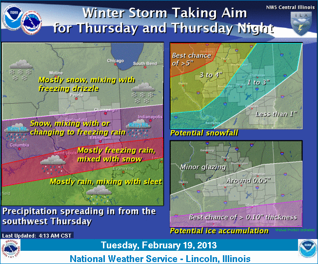
Friday. Snow will develop in central Illinois during the day
Thursday. The snow will overspread all of the area by early Thursday
afternoon before becoming mixed with sleet and freezing rain late in
the day, especially along and south of Interstate 70. Mixed
precipitation will likely continue Thursday evening, with mainly
snow north of I-74 and freezing rain and sleet also possible south
of I-74. The mixed precipitation will taper off to more of a
freezing drizzle or very light snow combination later Thursday
night. Current indications suggest the potential for 3 to 5 inches
of snow, especially along and north of I-72, with heavier snowfall
amounts likely west of Illinois.

[to top of second column] |

Even though the steady snowfall is expected to taper off overnight
Thursday, there could be an extended period of light freezing rain
or drizzle overnight Thursday into early Friday morning as
temperatures slowly moderate during the night Thursday. Most areas
are expected to remain below freezing overnight, with only far
southeast Illinois near Lawrenceville seeing the mercury near or
just above the freezing mark through early Friday morning. At this
point, ice accumulations could range from one-tenth to two-tenths of
an inch from I-72 south, with higher amounts possible in southwest
Illinois, where winter storm watches are posted Thursday.
If you have plans for traveling anywhere across the Midwest from
Thursday into Friday morning, especially west of the Mississippi
River, you should keep up-to-date with the latest information on
this developing winter storm. The combination of snow and ice on
area roadways will make for hazardous driving conditions on
untreated roads.
___
Graphical depiction:
http://www.crh.noaa.gov/wxstory.php?site=ilx
(Or see below for graphic posted by the
National Weather Service on Tuesday.)
For updates, check http://www.crh.noaa.gov/ilx/.
[Text from National Weather Service,
Lincoln office] |